From the air, the Ecuadorian rainforest looks like an endless green ocean. No straight lines. No right angles. Just trees and shadows.
Then the LiDAR images came back.
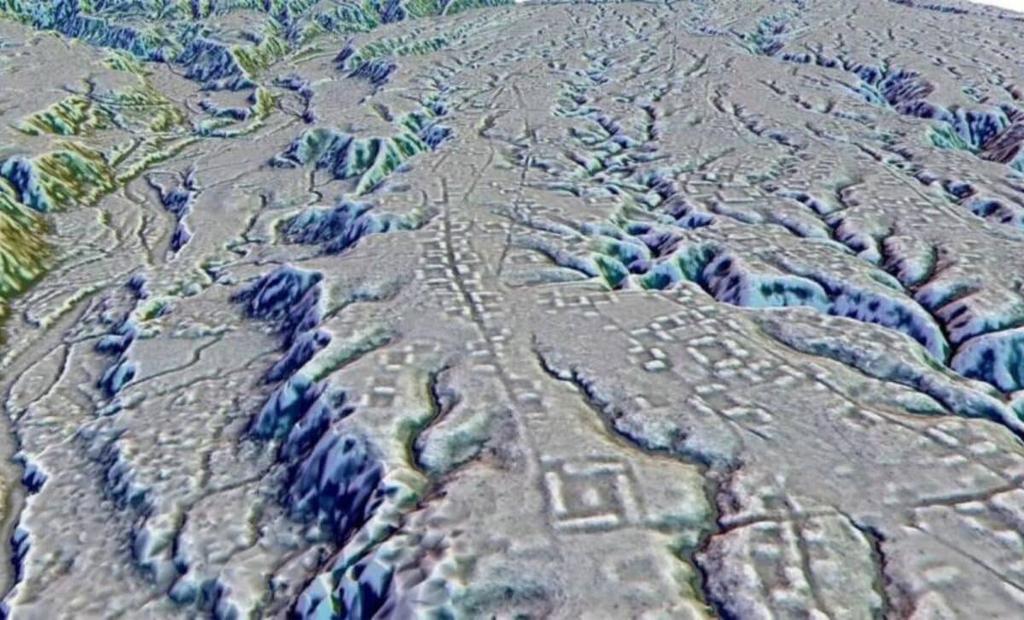
Under that canopy, researchers saw grids. Causeways. Rectangular plazas. More than 6,000 earthen mounds arranged with the kind of precision you expect from a city planner, not a jungle.
What LiDAR revealed in the Ecuadorian Amazon is a 2,500-year-old network of planned settlements, linked by roads and organized around ceremonial centers. In plain terms: there were cities in the western Amazon long before Europeans arrived, and they were anything but “primitive.”
This find does not just add a new dot to the map. It forces historians and archaeologists to rethink what the Amazon was, who lived there, and how they shaped one of the world’s largest ecosystems.
What did LiDAR actually find in the Ecuadorian Amazon?
LiDAR, short for Light Detection and Ranging, is basically laser scanning from the air. A device mounted on a plane or helicopter fires pulses of light at the ground and measures how long they take to bounce back. Software then strips away the vegetation and produces a digital model of the terrain beneath.
In the Ecuadorian Upano Valley, on the eastern slopes of the Andes, that digital terrain model did not look natural at all.
Researchers identified more than 6,000 earthen mounds arranged in geometric patterns. Many were built around large plazas. Straight, raised roads ran between settlements, some for several kilometers. There were terraces, canals, and what look like defensive earthworks.
The dates come from radiocarbon samples and earlier excavations in the same region. The core occupation of this urban network appears to begin around 500 BCE and continue, with changes, for more than a thousand years. That makes it roughly contemporary with the classical Greek world and pre-Roman Italy.
One clear sentence version: LiDAR in Ecuador’s Upano Valley revealed a 2,500-year-old system of planned settlements, roads, and mounds that functioned as a low-density urban network in the western Amazon.
For decades, many scholars assumed the Amazon could not support dense, long-lasting settlements because of its poor soils and seasonal flooding. These images show the opposite: people were not just surviving there, they were organizing large communities with planned layouts and long-distance connections. So the discovery matters because it shatters the old picture of the Amazon as an untouched wilderness full of scattered bands.
Who built these Amazonian cities and when did they rise?
The Upano Valley is not a blank spot in the archaeological record. Excavations there since the late 20th century have uncovered pottery, house platforms, and evidence of agriculture. Two cultural phases are especially tied to these new LiDAR-mapped sites: the Kilamope and Upano cultures.
The Kilamope phase begins around 500 BCE. These people were already building earthen platforms and using ceramics with distinctive designs. The Upano phase follows, stretching into the first millennium CE. The LiDAR evidence suggests that by this time, the region had a network of settlements linked by roads and organized around ceremonial centers with plazas and larger mounds.
We are not talking about a single megacity like Tenochtitlan. Think instead of a constellation of towns and villages, each with its own central plaza and mounds, tied together by causeways. Archaeologists sometimes call this “low-density urbanism.” It is urban life spread out, integrated with fields and forest, rather than piled into stone tenements.
Who exactly these people were in linguistic or ethnic terms is harder to say. The written record does not begin until Spanish chroniclers arrive in the 16th century, and by then, the societies that built these mounds had long since changed or vanished. Modern Indigenous groups in the region, such as the Shuar and Achuar, are heirs to long local histories, but direct cultural continuity over 2,000 years is difficult to trace with certainty.
Still, the dates matter. These cities rose centuries before the Roman Empire and were occupied for generations. That means Amazonian urbanism was not a late, marginal experiment. It was one of the world’s early experiments in organizing large communities in a tropical forest.
So this phase of building and planning matters because it anchors Amazonian complexity deep in time, showing that advanced societies there were not a brief pre-Columbian flourish but a long-running tradition.
How were these Amazonian cities planned and connected?
From the LiDAR images and ground checks, a pattern emerges. Each major site has a central plaza, often rectangular, flanked by larger mounds. Around this core, smaller platforms and house mounds spread out. The whole thing is oriented in consistent directions, suggesting shared planning principles or cosmological ideas about space.
Roads are the most striking feature. These are not informal paths. They are straight, raised causeways, some several meters wide, cutting through the forest and linking one settlement to another. In some cases, they radiate from a central site like spokes from a wheel.
Urban planning in the Amazon did not rely on stone. It used earth. People moved enormous volumes of soil to build platforms, embankments, and terraces. They reshaped hillsides and river edges. In a humid, erosion-prone environment, keeping these features stable for centuries required constant maintenance and social coordination.
There is also evidence of water management. Some embankments and ditches look like they were designed to control runoff or channel water. In a region where too much water is often more of a problem than too little, that kind of engineering would have been essential.
One snippet-ready line: These Amazonian cities were low-density urban networks built from earth, with plazas, mounds, and straight causeways that stitched dozens of settlements into a single planned system.
Planning on this scale matters because it points to organized labor, shared rules, and some form of leadership or governance. You do not get kilometers of straight road and standardized plazas from a few families acting on their own. So the layout of these sites is one of the strongest clues that we are dealing with complex societies, not scattered hamlets.
How did people farm and survive in an “impossible” environment?
For a long time, the standard line about the Amazon was simple: the soils are poor, so you cannot have large, permanent populations. The forest was seen as a natural ceiling on social complexity.
That view has been crumbling for years, and the Ecuadorian LiDAR results push it further. You do not get thousands of mounds and planned roads without a reliable food base.
Archaeological work in the wider Amazon has revealed several strategies that likely supported these cities:
First, diversified agriculture. People grew manioc (cassava), maize, sweet potatoes, and other crops suited to tropical conditions. They mixed fields with orchards of fruit and nut trees. This created a patchwork of productive zones rather than single-crop fields.
Second, soil engineering. In other parts of the Amazon, archaeologists have documented terra preta, or “Amazonian dark earth,” human-made soils rich in charcoal, bone, and organic waste. These soils are far more fertile than the natural ones and can last for centuries. While the specific extent of terra preta in the Upano Valley is still being studied, the broader pattern suggests that Amazonian farmers knew how to create and maintain better soils.
Third, managed forests. Indigenous people did not simply clear and abandon. They pruned, transplanted, and encouraged useful species. Over time, this created what some researchers call “cultural forests,” where the apparent wildness hides generations of human selection.
Finally, proximity to the Andes gave the Upano Valley an advantage. Rivers flowing from the mountains carry nutrient-rich sediments. That, combined with terraces and embankments, could support more intensive cultivation than in some lowland zones.
So the survival strategies matter because they dismantle the old idea that the Amazon was a natural limit on complexity. Instead, they show that people learned to engineer soils, water, and forests to support urban life in a place many outsiders wrote off as uninhabitable at scale.
Did this really “rewrite everything” about Amazonian history?
Claims that a single discovery “rewrites everything” are usually exaggerated. In this case, the Ecuadorian LiDAR fits into a pattern that has been building for decades, but it does push that pattern into sharper focus.
Since at least the late 20th century, archaeologists have been finding evidence of large, organized societies across the Amazon basin. In Bolivia’s Llanos de Mojos, LiDAR has revealed causeways, canals, and mound complexes. In Brazil, the so-called “geoglyphs” and ring ditches point to large-scale earthworks. Near the Xingu River, researchers have mapped networks of villages connected by roads and surrounded by defensive ditches.
The Ecuadorian sites add several new elements. They are among the oldest clearly urban-style networks in the western Amazon, with dates reaching back to around 500 BCE. They show standardized planning over a wide area, not just isolated centers. And they sit at the interface between the Andes and the lowland forest, a zone that may have been a corridor for ideas, crops, and people.
So no, this discovery does not come out of nowhere. It confirms what many specialists have been arguing: that pre-Columbian Amazonia was home to diverse, complex societies, some of which built urban networks.
But it does rewrite one stubborn popular image. The idea of the Amazon as a “pristine wilderness” barely touched by humans before 1500 is hard to sustain when you can see thousands of mounds and roads under the trees. So the real shift is not from “nothing” to “cities,” but from “empty forest” to “long-inhabited, engineered region.”
What happened to these Amazonian cities?
Here the record gets murkier. The LiDAR gives us shapes. Radiocarbon dates give us time brackets. Explaining collapse or transformation is harder.
The main occupation of the Upano Valley mounded sites seems to fade by around 600–900 CE, though exact dates vary by location. That is centuries before Europeans arrive in South America. So we are not looking at a simple story of Spanish conquest wiping out a single city-state.
Several factors could be in play:
Environmental change is one candidate. Shifts in rainfall patterns, river courses, or soil exhaustion could have made some areas less attractive. In a region where water is both a resource and a hazard, even modest climate shifts can have big effects.
Social and political change is another. Power structures can fracture. Trade routes can shift. New groups can move in. The Andes, just upslope, saw the rise and fall of multiple complex societies long before the Inca. The Upano Valley may have been tied into those wider rhythms.
Disease and conflict are also possible. Even without Europeans, pathogens and warfare can reshape populations. Archaeologists have found defensive ditches at some Amazonian sites, a sign that life was not always peaceful.
What we can say is that by the time Spanish chroniclers were writing about the region, the specific urban network mapped by LiDAR was no longer functioning in its original form. Forest had reclaimed plazas and roads. Later Indigenous societies occupied a different pattern of settlements.
So this uncertain ending matters because it reminds us that Amazonian history is not a straight line from “simple” to “complex” to “collapse.” It is a series of experiments in living with a powerful environment, some of which lasted centuries and then gave way to new arrangements.
Why this discovery still matters for the Amazon and its people
On one level, the LiDAR results are about the past. They tell us that 2,500 years ago, people in the Ecuadorian Amazon were organizing cities, building roads, and reshaping the land.
On another level, they feed straight into present-day debates about the Amazon.
For governments and companies, the idea of the Amazon as “empty” or “unused” has often been a convenient excuse for clearing forest for ranching, mining, or dams. If the land is seen as a blank slate, then there is no history to respect and no long-term human investment to consider.
Archaeology is tearing up that blank slate. The more we map, the more we see that much of the Amazon is a cultural landscape shaped by centuries of Indigenous management. Even when the visible earthworks are gone, the composition of the forest, the distribution of useful trees, and the soils themselves carry human fingerprints.
For Indigenous communities today, this matters on several levels. It supports claims that their ancestors were not marginal squatters but builders and managers of complex systems. It also backs up traditional knowledge about how to live with the forest rather than strip it.
There is a scientific angle too. Understanding how past societies engineered soils, managed water, and maintained biodiversity in a tropical forest could inform modern efforts to keep the Amazon from tipping into large-scale degradation.
So the legacy of these hidden cities is not just a new chapter in ancient history. It is a reminder that the Amazon has long been a human place, and that any serious plan for its future has to start by admitting how much of its past we are only now learning to see.
Frequently Asked Questions
What did LiDAR discover in the Ecuadorian Amazon?
LiDAR surveys in Ecuador’s Upano Valley revealed a 2,500-year-old network of planned settlements, including more than 6,000 earthen mounds, rectangular plazas, and straight raised roads linking multiple sites. The pattern points to low-density urbanism rather than scattered villages.
How old are the newly found Amazonian cities?
Radiocarbon dating and earlier excavations suggest that the main occupation of these mounded sites began around 500 BCE and continued for many centuries, into the first millennium CE. That makes them roughly contemporary with early classical civilizations in other parts of the world.
How could large societies survive in the Amazon rainforest?
Pre-Columbian Amazonians used diversified agriculture, including manioc and maize, managed forests rich in useful trees, and in many areas created fertile anthropogenic soils known as terra preta. In the Upano Valley, proximity to nutrient-rich Andean rivers and earthworks for water control likely supported stable food production.
Does this discovery prove that the Amazon was full of ancient cities?
The Ecuadorian LiDAR results add to growing evidence of complex societies across the Amazon, including road networks, earthworks, and large settlements in Bolivia and Brazil. They do not mean every part of the forest was urban, but they do show that significant regions supported organized, long-lasting communities rather than sparse, isolated bands.