ANGKOR, CAMBODIA – it’s a phenomenon that archaeologists are struggling to explain: huge fields of row upon row of earthen dome-shaped mounds, just sitting there in grids, spirals, and other geometric patterns in Cambodia’s ancient 1,000 year old cities.
For years, the Cambodian Archaeological Lidar Initiative (CALI) have been using radar technology to penetrate into areas of the Cambodian rainforest that archaeologists haven’t been able to get to. They’re hoping to find signs of medieval Cambodian civilization (The Khmer Empire), near large temple complexes, like Angkor Wat, where the Khmer Empire was centered around.
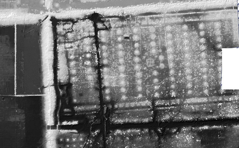
The researches with CALI were scanning the area around Angkor Wat and Preah Khan using the radar equipment attached to helicopters. They were looking for cities, what they found were strange earthen mound gardens. The scans were taken in 2015. They covered 735 square miles of the Cambodian rainforest, and the pictures taken have been invaluable in piecing together the history of the Khmer Empire when it flourished over a 1,000 years ago.
The Khmer Empire was a powerful Hindu-Buddhist empire in Southeast Asia. It covered land not only in Cambodia, but also parts of Laos, Thailand, and southern Vietnam. Angkor, where Angkor Wat is located, at its height, was the largest urban center in the world. It reached its golden age in the 12th century, and began to decline in the 14th. During its rule, the great Empire traded with China, Japan, and India.
A special note is that women in the Khmer Empire held rights that other nations denied them. The primary merchants were women. They enjoyed significant rights and freedom, and married early so as to avoid early death from pregnancy and giving birth. A Chinese trader named Zhou Daguan wrote that any Chinese man who wanted to do trade in Angkor would have to learn to respect women, or else he’d be shut out of the economy!
The Empire was built upon the network of agricultural communities of rice farmers and fishermen. They had advanced farming techniques, including extensive irrigation that allowed them to produce enough food to feed their vast population many times over, allowing for other people, who were not farmers, to have time to become traders and artisans. So, the Khmer Empire flourished and traded with everyone around them, and the emperors were able to devote the Empire’s energy in times of peace to create art and huge, majestic monuments like the famous Angkor Wat.
So, where do these gardens of earthen mounds fit in? Hoping they were tombs or even trash piles, the archaeologists dove in, but the mounds have yielded nothing of archaeological value. They’re just dirt, and the researchers with CALI are entirely baffled as to their original function.
Each geometric shape was constructed using a different pattern. They’re located by water sources and temple complexes. The mounds near Angkor Wat take the form of spirals, but the designs at Preah Khan are arranged in grids.
Their only guess is that the mounds were used as a sort of horticultural raised-field system, due to their proximity to water and the temples. Perhaps the monks in the temples were involved in some kind of specialized plant production, but without further information, nobody can say for sure.
The CALI researchers and volunteers will keep looking over the laser data they’re collecting in Cambodia and compare it with comparable sites around the span of the Khmer Empire. Perhaps their research will reveal the purpose of these strange, enigmatic gardens of empty mounds. The archaeologists promise to let us know.
“Surface surveys and excavations of these mounds have revealed little of archaeological interest, and they remain among the most enigmatic features of Khmer landscape archaeology,” – Damian Evans, Archaeologist with the Cambodian Archaeological Lidar Initiative